Video
GARDEN ROUTE | KAROO NEWS & VIDEO - The South African Weather Service (Saws) has released its latest weather forecast for Friday, 27 September.
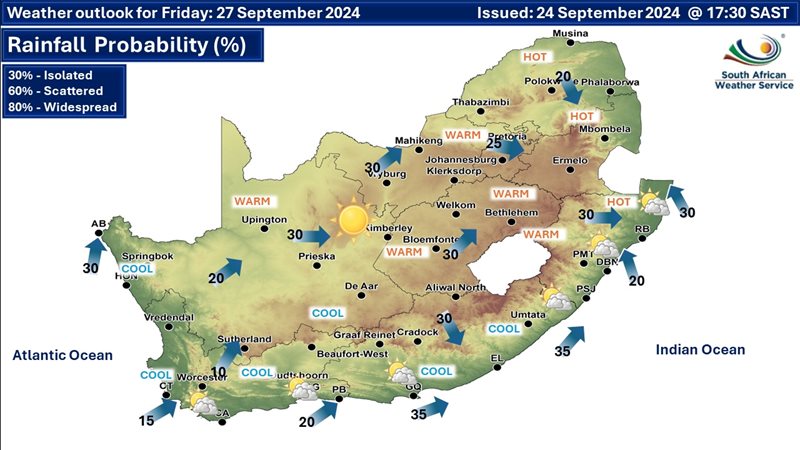
The weather service has warned of extremely high fire danger in Limpopo, Gauteng, Mpumalanga, the North West, the Northern Cape, the Eastern Cape, and KwaZulu-Natal; otherwise, warm and windy conditions will dominate.
Here’s what you need to know.
Weather warnings, 27 September
Western Cape:
Western Cape residents can expect mostly cloudy conditions along the south-west and south coast where it will be cold in places; otherwise, it will be partly cloudy and cool, but fine and warm over the interior by the afternoon.
The region’s expected UVB sunburn index is “high.”
Residents should take the necessary precautions against prolonged sun exposure.
Eastern Cape (western half):
There will be morning fog in places; otherwise, it will be fine and cool, but warm over the interior.
Eastern Cape (eastern half):
There will be morning fog in places; otherwise, it will be partly cloudy and warm.
Snow forecast
According to Snow Report, "The snow indicated in the west is currently expected from Saturday evening but mostly late through Sunday and early on Monday. The heaviest snow is showing up for the Western Cape mountains with over 120cm currently indicated for the highest peaks, although the low-level snowfall is likely to be light according to current data."
VIDEO: Weekend weather forecast
"The Swartberg Pass near Oudtshoorn and some of the higher mountain passes around Graaff-Reinet might get a light dusting later on Sunday and Monday.
"No weather warnings have been issued by the South African Weather Service for this snow event at this stage".
‘We bring you the latest Garden Route, Hessequa, Karoo news’