KNYSNA NEWS - "Is Knysna ever going to have a bypass?" This question has been raised anew following the tragic demise of 76-year-old Jackie Stroebel who was run over by a truck in Main Road on Friday 22 November.
The past four decades have seen a robust to-and-fro between various decision-making factions in town which, at one point, saw five different proposals to divert traffic from Knysna's CBD.
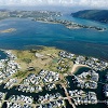
The environmental impact assessment (EIA) report cast doubts on two routes (the so-called "forest" and "northern" routes) which constituted wide berths around Knysna to the north.
'Proposed route'
The most enduring proposals were two routes closer to Knysna that were planned to cross the Knysna River by the Red Bridge, pass through parts of Welbedacht, Narnia (and the Montessori School) and then along the Salt River through Green Acres and a section of Concordia to meet the N2 again at Brackenhill on the Plettenberg Bay road. The longer version of these routes came to be known as the "proposed" route.
But one of the last nails in the coffin of these two notions were sunk in April this year when the department of environmental affairs (DEA) finally rejected the SA National Roads Agency (Sanral) proposal for a toll highway to bypass Knysna's CBD. Sanral was hoping to get the go-ahead for one of two recommended N2 bypass routes, but concerns raised in the project's EIA by Coastal and Environmental Services resulted in the DEA rejecting plans for both routes on 17 April this year – some 10 years after the EIA had been completed.
Strong support
The DEA's rejection was issued despite strong support from traffic specialists hired by the municipality for the bypass as the only possible option to ease traffic, pollution and congestion in the CBD.
Although it raised awareness of the environmental loopholes facing the bypass project, the EIA also attested to the necessity of such a bypass.
In response to queries, the municipality last week issued a statement regarding the DEA's decision, saying: "Sanral cancelled the N2/bypass without consultation." But Sanral this week responded to enquiries by referring to the DEA's rejection in April.
Sanral had, however, already donated the 72 hectares of land set aside as servitude for the "proposed'' bypass to the department of human settlements in February 2016. It told KPH this week it needed more time to answer the question as to why and how the decision to donate the land had come about.
Various versions
With hopes of the "proposed" bypass waning in the wake of the DEA's rejection, the town is left with only one option.
Or rather various versions of one option utilising Waterfront Drive as the alternative route. This option (which later became known as the Do Minimum option) was first proposed in the late 1980s.
The suggestion to divert one-way traffic in opposite directions along Waterfront and Gordon streets was first tabled in the municipality's traffic management plan of 2005.
According to traffic experts, the N2 currently carries over 1 000 trucks a day, a number that is expected to grow alongside local private and tourist traffic.
Municipal traffic chief Anthony Bans, however, still believes it's safer to have the trucks use Main Road because the layout of the eastern end of Waterfront Drive (near Food Lover's Market) isn't able to accommodate heavy vehicles and their loads. Besides, he says, "There's no municipal bylaw compelling us to divert truck traffic onto Waterfront Drive."
But because no decision was made to implement the Gordon Street aspect of the plan, this constitutes buying property and buildings needed for the additional road space which the municipality lacked the funding to implement. Amid laments that Waterfront Drive is not being used for the purpose of alleviating traffic flow down Main Road as intended, criticism has been rife concerning the turns into Waterfront Drive from the N2 being too narrow for larger vehicles.
Different opinions
In a letter to KPH last week, Margot Paulsen suggested that one solution is for the traffic department to begin diverting trucks off Main Road onto Waterfront Drive. "If they have a problem with lorries turning at the top traffic lights back onto the N2, fix it!" she said.
Retired Knysna architect Louis de Swart believes the solution lies in creating a one-way traffic flow from east to west along Waterfront Drive and another one-way flow west to east along Main Road. He drew up plans for this proposal which he submitted to the municipality in 2007 and again in 2012.
According to long-standing Knysna resident Lesley Satchell, Waterfront Drive was never meant to be an alternative diversion for heavy vehicles "built by our municipality at Knysna's own expense for use by local residents who wish to pass the congestion in town". (See Letters page.)
Do-minimum plan
But, according to former mayoral committee member and councillor Andrew Finn, both De Swart and Satchell are correct. "Even though Waterfront was not originally designed for heavy vehicles, it was later under consideration as an alternative option to Main Road," he said.
Failing the development of the Do Minimum plan, there's what the CES environmental impact assessment calls the Do Nothing plan: construct no highway and continue to use the N2 which runs through the centre of the CBD with all the inconvenience and risks involved.
'We bring you the latest Knysna, Garden Route news'