



GARDEN ROUTE NEWS - The Western Cape is bracing for a dramatic change in weather as a cold front moves across the province, bringing very cold, wet and windy conditions from Wednesday.
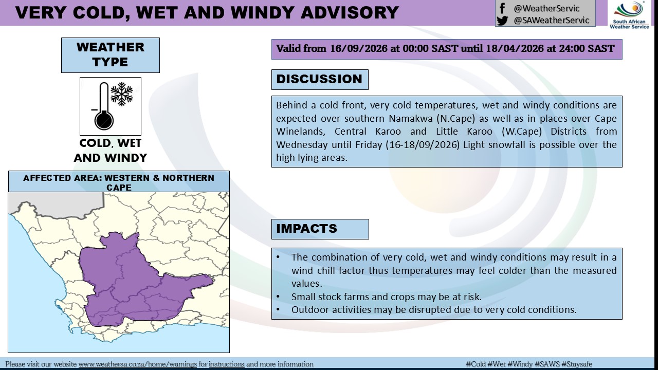
According to the South African Weather Service (SAWS), the weather system is expected to affect parts of the Western Cape and Northern Cape from Wednesday, 16 September, through Friday, 18 September, with light snow possible over high-lying areas.
The SAWS advisory warns that the combination of very low temperatures, rain and wind could make conditions feel significantly colder than the actual measured temperatures because of the wind-chill effect.
Areas identified in the advisory include parts of the Cape Winelands, Central Karoo and Little Karoo, while very cold, wet and windy conditions are also expected over southern Namaqualand in the Northern Cape.
Snow possible on the higher ground
While snow is not expected across the province, SAWS says light snowfall is possible over high-lying areas.
For residents in mountainous and elevated areas, the possibility of snow adds another dimension to what is expected to be an unusually cold spell for mid-September.
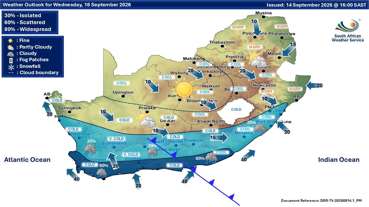
The weather outlook for Wednesday also shows a broad swathe of very cold and cold conditions across the southern parts of the country, with rain expected in parts of the Western and Eastern Cape.
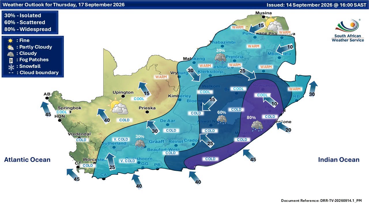
For George and surrounding areas, the forecast points to a sharp drop in temperatures on Wednesday, accompanied by periods of rain. Further showers and cool conditions are expected through Thursday and into Friday.
Cold, wet and windy conditions could cause disruption
The combination of rain, wind and low temperatures can create a number of challenges.
SAWS warns that small stock farms and crops may be at risk, while outdoor activities could be disrupted by the very cold conditions.
The wind-chill factor is also important. A temperature reading on a thermometer does not necessarily reflect how cold it feels to people exposed to wind and rain.
Motorists travelling through mountainous areas should be particularly cautious, as wet roads, poor visibility, strong winds and possible snow or ice at higher elevations can make driving conditions more difficult.
Residents are advised to check weather updates before travelling and to allow additional time if conditions deteriorate.
Garden Route gets a taste of winter again
For the Garden Route, the change will be particularly noticeable.
After a relatively mild Tuesday, Wednesday is expected to bring periods of rain and much cooler temperatures, with the mercury struggling to reach the mid-teens.
The forecast remains cool and unsettled on Thursday, with showers possible, while Friday is expected to remain cloudy and cool with further rain.
The unsettled weather is likely to be welcomed by gardens and water-conscious residents, however, particularly following the recent rainfall recorded across the Garden Route.
Prepare for the cold snap
With spring already underway, many residents may have packed away heavier winter clothing or stopped thinking about cold-weather preparations.
A few simple precautions can make the next few days more comfortable:
- Bring vulnerable pot plants indoors or move them to a sheltered position.
- Check that pets have a warm, dry place to sleep.
- Secure loose outdoor furniture, umbrellas and other items that could be blown around by strong winds.
- Check gutters and drains before the rain arrives and clear any leaves or debris that could cause blockages.
- Take extra care on wet roads, particularly at night and in mountainous areas.
- If travelling through areas where snow is possible, check road and weather conditions before setting out.
For farmers and smallholders, the very cold conditions may require additional protection for vulnerable livestock and crops.
A reminder that spring can still bite
The arrival of warmer days does not mean winter has completely disappeared.
September is a transition month in the Western Cape, and powerful cold fronts can still sweep across the province, bringing conditions that feel more like mid-winter than early spring.
This week's system is expected to move through relatively quickly, but residents can expect a distinctly colder few days before conditions begin to moderate again.
For now, the message from the weather service is simple: prepare for the cold, rain and wind, and keep an eye on the forecast if you are travelling or spending time outdoors.
‘We bring you the latest Garden Route, Hessequa, Karoo news’