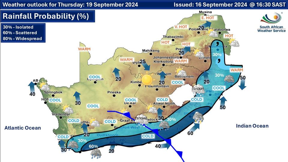
GARDEN ROUTE | KAROO NEWS - According to Weather SA, a cold front is approaching from the West. Here is what you can expect on Wednesday.
Western Cape:
Mostly cloudy and cool to cold, with rain and showers expected along the south coast by the afternoon, spreading along the south-coast and adjacent interior by the evening, while clearing is anticipated from the west.
Morning fog likely in the West Coast District. The wind along the coast will be moderate to fresh westerly to north-westerly, reaching strong to near gale along the south coast by mid-morning.
It will become strong to gale force south-westerly in the afternoon but south-east along the southwest and West Coast.
The expected UVB sunburn index: Moderate.
Eastern Cape (western half):
Cloudy in places in the east at first, otherwise fine and cool, but warm in places over the interior. It will become cloudy along the coast in the afternoon with light rain in places.
The wind along the coast will be moderate to fresh south-westerly, becoming westerly in the evening.
Eastern Cape (eastern half):
Cloudy with scattered showers and thundershowers in the north and east at first, otherwise fine and cool to warm, becoming cloudy south of the escarpment in the evening with isolated showers and rain in areas adjacent to the coast, but scattered along the coast south of Port St Johns.
The wind along the coast will be moderate to fresh south-westerly.
Possibility of snow
According to Severe Weather and Information Centre SA, from Thursday 19 September through to Saturday 21 September we can expect to see some widespread snowfalls across 7 provinces.
A strong cut-off low with a ridging high pressure system will bring cold air from the south creating good conditions for snow.
This is still an advanced forecast and is subject to change.


‘We bring you the latest Garden Route, Hessequa, Karoo news’